
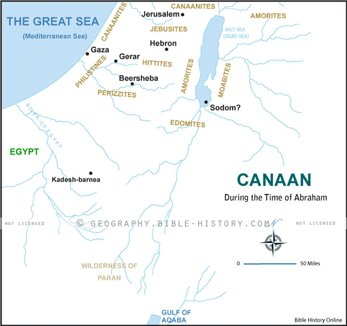
The Map of Canaan During the Time of Abraham is a captivating portal to an ancient world, inviting you to traverse the very landscapes that played a pivotal role in the life of the patriarch Abraham. With meticulous attention to historical and geographical details, this map offers a vivid glimpse into a bygone era.
As you explore the map, you'll witness the geographical contours of Canaan, a land that stretches from the Mediterranean coastline to the Jordan River and encompasses present-day Israel, Palestine, and parts of neighboring countries. The map highlights key cities and regions mentioned in the biblical narratives, including Hebron, Shechem, Bethel, and the Plains of Mamre.
What sets this map apart is its focus on the era of Abraham, the legendary biblical figure often referred to as the "Father of Faith." Annotations and illustrations throughout the map guide you through Abraham's journeys and encounters, from his departure from Haran to his sojourns in various locations within Canaan.
This map is a valuable resource for scholars, historians, theologians, and anyone interested in the biblical world. It offers a unique opportunity to immerse yourself in the geography of Abraham's time, gain insights into the challenges and triumphs of his journey, and appreciate the cultural and historical context of his story.
Whether you approach it from a faith perspective or as a student of history, the Map of Canaan During the Time of Abraham provides a rich and educational experience. It beckons you to step into the sandals of Abraham, to walk the same paths he trod, and to gain a deeper appreciation for the enduring legacy of his faith.
Embark on a captivating journey through biblical history with this map, as you navigate the terrain of Canaan during the time of Abraham, and discover the profound impact of this patriarch's journey on the course of human civilization and faith traditions.
Blank Topo Map of The World
Abraham’s Journey
The Captivity of Judah (586-516 B.C.)
The Fall of Judah 586 B.C.
The Northern Kingdom of Israel
The Southern Kingdom of Judah
The Divided Kingdom
The Fertile Crescent
Ur of the Chaldees
Shechem in Old Testament Times
Prophets, Kings, and Nations
Jesus Last Passover
New Testament Israel
New Testament Places
Old Testament Israel
Provinces of the Roman Empire
Israel during David’s Kingdom
David’s Kingdom
Cities of the New Testament 4
Cities of the New Testament 3
Cities of the New Testament 2
Mediterranean Sea
Cities of the New Testament
First Century Jerusalem
Empire of David and Solomon
David’s Kingdom
Israel Under Rehoboam
Ophir and Tarshish
The Period of the Kings
Ramoth Gilead
Samaria
Solomon’s Temple
Zarephath and MT Carmel
Jabesh Gilead and Tribes
Judah in the Time of David
Kingdom of Saul
Kirjath Jearim
Michmash
Mount Gilboa in the Time of David
Nob Davids Flight
Shiloh
Israel and Judah
Assyrian Empire Under Esarhaddon
Assyrian Empire Under Sennacherib
Captivity of 10 Tribes
Events in 2 Kings
The Khabur River
Israel and Syria
Captives From Judah
Kingdom of Jeroboam
Mesha’s Kingdom
Pharaoh Necho Battles King Josiah at Megiddo
Babylonian, Mede and Persian Empires
Samaria and Nearby Territories
Syria at its Height
Hebron
Mahanaim
1949 Map of Israel With Boundaries
First & Second Journeys of Paul
Journeys of the Apostles
Paul’s Third Missionary Journey
Saul’s Journey to Damascus and Arabia
Paul’s Final Visits
Paul’s 1st Missionary Journey
Paul’s 2nd Missionary Journey
Paul’s 3rd Missionary Journey
Paul’s Voyage to Rome
Phillip Journeys to Samaria and Gaza
Judah at the Time of Amos
Empire of Alexander the Great
Israel Under the Maccabees
Galilee During Maccabees
Idumea Intertestamental Period
Kingdom of the Ptolemies
Kingdom of the Seleucids
Ptolemaic Egypt Seleucid Asia
The Roman World
Kingdom of Ptolemies and Seleucids
The World During the 6TH Century BC
Mount Horeb
The Red Sea
The Exodus
Ezra’s Journey to Restore Jerusalem
Israel and Judah During Hosea’s Time
The Ancient World
Canaan During the Time of Abraham
The City of Shechem
Supposed Location of the Garden of Eden
The Land of Israel in Genesis
The Jordan River
The Kingdom of Nimrod
Mount Ararat and Mesopotamia
The Descendants
Sodom and Gomorrah
The Kingdom of Egypt
The Hamites
The Kingdom of the Hittites
Ur of the Chaldees
Judah at the Time of Haggai
Jesus Passes Through Samaria