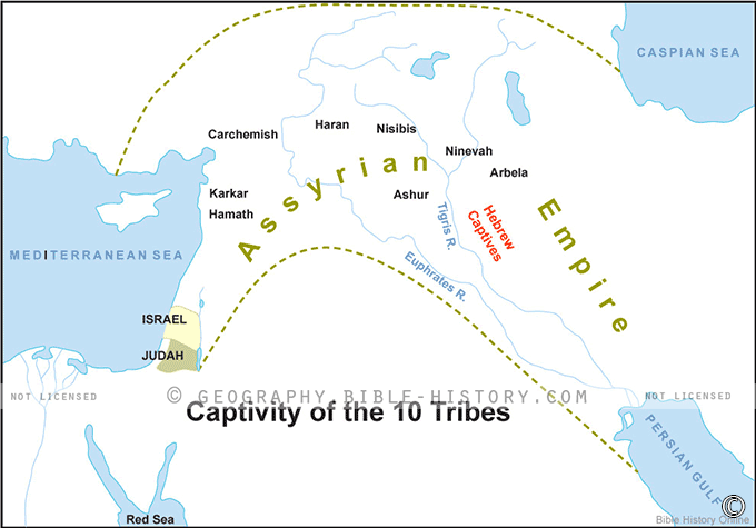

The map of the Captivity of the 10 Tribes is a poignant representation of a significant historical event that shaped the course of ancient Israel's history. This map offers a visual insight into the forced exile and dispersal of the northern kingdom of Israel's ten tribes, which occurred in the 8th century BCE. Here is a description of this historical map:
Geographical Context:
The map covers the region of the northern kingdom of Israel during its final years before the Assyrian conquest. It encompasses the territories inhabited by the ten tribes, including areas in present-day northern Israel and parts of modern Syria.
Key Locations and Routes:
- Samaria: The capital city of the northern kingdom, Samaria, is a central point on the map. It was a symbol of Israel's power and prosperity before its fall.
- Assyrian Routes: The map illustrates the routes taken by the Assyrian forces as they invaded Israel and eventually led the Israelite population into captivity. The Assyrian Empire's military campaigns are depicted with arrows and markers.
- Exile Destinations: The map showcases regions and cities where the ten tribes were deported to by the Assyrians, such as regions in Mesopotamia and the eastern parts of the Assyrian Empire.
Timeline of Events:
A chronological timeline on the map provides a historical context, marking key dates and events leading up to and following the captivity, including the reigns of Israelite kings and the rise of the Assyrian Empire.
Religious and Historical Significance:
This map carries profound religious and historical significance as it depicts a pivotal moment in the biblical narrative. The captivity of the ten tribes marked the end of the northern kingdom of Israel and contributed to the division of the Israelite people into distinct groups.
Cultural and Societal Impact:
The map helps viewers understand the long-term consequences of the captivity, including the assimilation of the ten tribes into foreign cultures and the eventual loss of their distinct identity.
Modern Insights and Archaeological Findings:
In addition to its historical significance, the map also highlights areas where archaeological discoveries have provided insights into the lives of the exiled Israelites and the ancient world.
The map of the Captivity of the 10 Tribes is a powerful visual representation of a momentous event in the history of Israel. It allows viewers to contemplate the geographical and cultural transformation of the northern kingdom and reflects on the enduring impact of this ancient exile on the Israelite people.
Blank Topo Map of The World
Abraham’s Journey
The Captivity of Judah (586-516 B.C.)
The Fall of Judah 586 B.C.
The Northern Kingdom of Israel
The Southern Kingdom of Judah
The Divided Kingdom
The Fertile Crescent
Ur of the Chaldees
Shechem in Old Testament Times
Prophets, Kings, and Nations
Jesus Last Passover
New Testament Israel
New Testament Places
Old Testament Israel
Provinces of the Roman Empire
Israel during David’s Kingdom
David’s Kingdom
Cities of the New Testament 4
Cities of the New Testament 3
Cities of the New Testament 2
Mediterranean Sea
Cities of the New Testament
First Century Jerusalem
Empire of David and Solomon
David’s Kingdom
Israel Under Rehoboam
Ophir and Tarshish
The Period of the Kings
Ramoth Gilead
Samaria
Solomon’s Temple
Zarephath and MT Carmel
Jabesh Gilead and Tribes
Judah in the Time of David
Kingdom of Saul
Kirjath Jearim
Michmash
Mount Gilboa in the Time of David
Nob Davids Flight
Shiloh
Israel and Judah
Assyrian Empire Under Esarhaddon
Assyrian Empire Under Sennacherib
Captivity of 10 Tribes
Events in 2 Kings
The Khabur River
Israel and Syria
Captives From Judah
Kingdom of Jeroboam
Mesha’s Kingdom
Pharaoh Necho Battles King Josiah at Megiddo
Babylonian, Mede and Persian Empires
Samaria and Nearby Territories
Syria at its Height
Hebron
Mahanaim
1949 Map of Israel With Boundaries
First & Second Journeys of Paul
Journeys of the Apostles
Paul’s Third Missionary Journey
Saul’s Journey to Damascus and Arabia
Paul’s Final Visits
Paul’s 1st Missionary Journey
Paul’s 2nd Missionary Journey
Paul’s 3rd Missionary Journey
Paul’s Voyage to Rome
Phillip Journeys to Samaria and Gaza
Judah at the Time of Amos
Empire of Alexander the Great
Israel Under the Maccabees
Galilee During Maccabees
Idumea Intertestamental Period
Kingdom of the Ptolemies
Kingdom of the Seleucids
Ptolemaic Egypt Seleucid Asia
The Roman World
Kingdom of Ptolemies and Seleucids
The World During the 6TH Century BC
Mount Horeb
The Red Sea
The Exodus
Ezra’s Journey to Restore Jerusalem
Israel and Judah During Hosea’s Time
The Ancient World
Canaan During the Time of Abraham
The City of Shechem
Supposed Location of the Garden of Eden
The Land of Israel in Genesis
The Jordan River
The Kingdom of Nimrod
Mount Ararat and Mesopotamia
The Descendants
Sodom and Gomorrah
The Kingdom of Egypt
The Hamites
The Kingdom of the Hittites
Ur of the Chaldees
Judah at the Time of Haggai
Jesus Passes Through Samaria