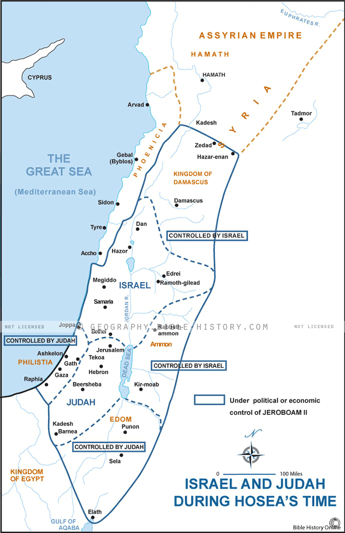

The Map of Israel and Judah During Hosea's Time is a captivating historical snapshot that immerses you in a pivotal era of biblical history. This meticulously designed map offers a unique opportunity to explore the geographic and geopolitical landscape of ancient Israel and Judah during the time of the prophet Hosea.
As you examine the map, you'll encounter the boundaries and key regions of these two kingdoms, which were at the heart of many biblical narratives. The map highlights cities such as Samaria, Jerusalem, and Bethel, allowing you to trace the paths of events and people central to Hosea's prophetic message.
This map also serves as a visual companion to the Book of Hosea in the Bible. It provides annotations and illustrations that bring to life the historical and spiritual context of the prophet's message. You can follow Hosea's journey and better understand the symbolism and significance of his actions and words in the context of the divided kingdoms.
The Map of Israel and Judah During Hosea's Time is a valuable resource for scholars, theologians, historians, and anyone interested in the biblical world. It offers a deeper understanding of the complexities of this period, including the political tensions, religious practices, and social dynamics that Hosea addressed in his prophetic ministry.
Whether you approach it from a religious or historical perspective, this map invites you to step back in time, to walk the ancient roads, and to engage with the spiritual and cultural heritage of Israel and Judah during the era of the prophet Hosea. It offers an immersive experience that fosters a greater appreciation for the profound messages contained within the pages of the Bible.
Dive into the pages of history and faith with the Map of Israel and Judah During Hosea's Time, and gain a deeper understanding of the prophet's timeless message and the context in which it was delivered.
Blank Topo Map of The World
Abraham’s Journey
The Captivity of Judah (586-516 B.C.)
The Fall of Judah 586 B.C.
The Northern Kingdom of Israel
The Southern Kingdom of Judah
The Divided Kingdom
The Fertile Crescent
Ur of the Chaldees
Shechem in Old Testament Times
Prophets, Kings, and Nations
Jesus Last Passover
New Testament Israel
New Testament Places
Old Testament Israel
Provinces of the Roman Empire
Israel during David’s Kingdom
David’s Kingdom
Cities of the New Testament 4
Cities of the New Testament 3
Cities of the New Testament 2
Mediterranean Sea
Cities of the New Testament
First Century Jerusalem
Empire of David and Solomon
David’s Kingdom
Israel Under Rehoboam
Ophir and Tarshish
The Period of the Kings
Ramoth Gilead
Samaria
Solomon’s Temple
Zarephath and MT Carmel
Jabesh Gilead and Tribes
Judah in the Time of David
Kingdom of Saul
Kirjath Jearim
Michmash
Mount Gilboa in the Time of David
Nob Davids Flight
Shiloh
Israel and Judah
Assyrian Empire Under Esarhaddon
Assyrian Empire Under Sennacherib
Captivity of 10 Tribes
Events in 2 Kings
The Khabur River
Israel and Syria
Captives From Judah
Kingdom of Jeroboam
Mesha’s Kingdom
Pharaoh Necho Battles King Josiah at Megiddo
Babylonian, Mede and Persian Empires
Samaria and Nearby Territories
Syria at its Height
Hebron
Mahanaim
1949 Map of Israel With Boundaries
First & Second Journeys of Paul
Journeys of the Apostles
Paul’s Third Missionary Journey
Saul’s Journey to Damascus and Arabia
Paul’s Final Visits
Paul’s 1st Missionary Journey
Paul’s 2nd Missionary Journey
Paul’s 3rd Missionary Journey
Paul’s Voyage to Rome
Phillip Journeys to Samaria and Gaza
Judah at the Time of Amos
Empire of Alexander the Great
Israel Under the Maccabees
Galilee During Maccabees
Idumea Intertestamental Period
Kingdom of the Ptolemies
Kingdom of the Seleucids
Ptolemaic Egypt Seleucid Asia
The Roman World
Kingdom of Ptolemies and Seleucids
The World During the 6TH Century BC
Mount Horeb
The Red Sea
The Exodus
Ezra’s Journey to Restore Jerusalem
Israel and Judah During Hosea’s Time
The Ancient World
Canaan During the Time of Abraham
The City of Shechem
Supposed Location of the Garden of Eden
The Land of Israel in Genesis
The Jordan River
The Kingdom of Nimrod
Mount Ararat and Mesopotamia
The Descendants
Sodom and Gomorrah
The Kingdom of Egypt
The Hamites
The Kingdom of the Hittites
Ur of the Chaldees
Judah at the Time of Haggai
Jesus Passes Through Samaria