
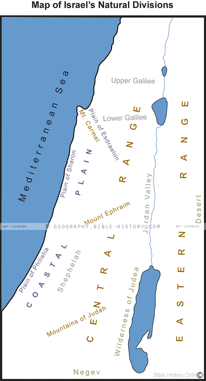
The "Map of Israel's Natural Division" offers a captivating exploration of the diverse and breathtaking landscapes that define the remarkable country of Israel. Meticulously designed and thoughtfully crafted, this map provides a visual narrative of the natural topography and geographical features that have shaped the nation's character and history.
Geographical Diversity:
Immerse yourself in Israel's stunning landscapes, from the lush greenery of the Upper Galilee to the arid expanses of the Negev Desert. This map vividly depicts the country's natural division, offering an overview of its various regions and their unique characteristics.
Mountain Ranges:
Trace the spine of Israel's mountainous terrain, including the Samarian and Judean Hills, which have played a pivotal role in the country's history and culture. Discover the peaks, valleys, and ancient paths that have witnessed countless events over millennia.
Coastlines and Beaches:
Explore the country's diverse coastline along the Mediterranean Sea, marked by pristine beaches, vibrant coastal cities, and historic ports. From Tel Aviv's lively beaches to the serene shores of the Red Sea, this map showcases Israel's maritime beauty.
Desert Wilderness:
Journey into the Negev Desert, a vast expanse of rugged terrain, awe-inspiring geological formations, and unique flora and fauna. The map highlights desert oases, ancient trade routes, and the unparalleled solitude of this arid wilderness.
Rivers and Lakes:
Discover Israel's freshwater resources, including the Jordan River and the Sea of Galilee (Lake Kinneret). These bodies of water have played vital roles in the country's history, culture, and ecology, and are intricately depicted on the map.
Nature Reserves and Parks:
Learn about the country's commitment to preserving its natural beauty through a network of nature reserves and national parks. The map identifies these protected areas, inviting you to explore their ecological significance and recreational opportunities.
Historical Landmarks:
Overlaying the natural features are markers highlighting historical and cultural landmarks, from ancient archaeological sites to modern cities. These symbols offer insights into the intersections of nature and civilization throughout Israel's history.
Hiking and Exploration:
If you're an outdoor enthusiast, this map provides information on hiking trails, adventure opportunities, and areas of ecological interest, making it an invaluable resource for planning your next exploration.
The "Map of Israel's Natural Division" is more than a geographical guide; it's a gateway to a land of incredible contrasts and a testament to the enduring connection between nature and the people of Israel. Whether you are a traveler, a nature lover, or a student of geography, this map invites you to embark on a visual journey through Israel's remarkable and diverse natural world.
Blank Topo Map of The World
Abraham’s Journey
The Captivity of Judah (586-516 B.C.)
The Fall of Judah 586 B.C.
The Northern Kingdom of Israel
The Southern Kingdom of Judah
The Divided Kingdom
The Fertile Crescent
Ur of the Chaldees
Shechem in Old Testament Times
Prophets, Kings, and Nations
Jesus Last Passover
New Testament Israel
New Testament Places
Old Testament Israel
Provinces of the Roman Empire
Israel during David’s Kingdom
David’s Kingdom
Cities of the New Testament 4
Cities of the New Testament 3
Cities of the New Testament 2
Mediterranean Sea
Cities of the New Testament
First Century Jerusalem
Empire of David and Solomon
David’s Kingdom
Israel Under Rehoboam
Ophir and Tarshish
The Period of the Kings
Ramoth Gilead
Samaria
Solomon’s Temple
Zarephath and MT Carmel
Jabesh Gilead and Tribes
Judah in the Time of David
Kingdom of Saul
Kirjath Jearim
Michmash
Mount Gilboa in the Time of David
Nob Davids Flight
Shiloh
Israel and Judah
Assyrian Empire Under Esarhaddon
Assyrian Empire Under Sennacherib
Captivity of 10 Tribes
Events in 2 Kings
The Khabur River
Israel and Syria
Captives From Judah
Kingdom of Jeroboam
Mesha’s Kingdom
Pharaoh Necho Battles King Josiah at Megiddo
Babylonian, Mede and Persian Empires
Samaria and Nearby Territories
Syria at its Height
Hebron
Mahanaim
1949 Map of Israel With Boundaries
First & Second Journeys of Paul
Journeys of the Apostles
Paul’s Third Missionary Journey
Saul’s Journey to Damascus and Arabia
Paul’s Final Visits
Paul’s 1st Missionary Journey
Paul’s 2nd Missionary Journey
Paul’s 3rd Missionary Journey
Paul’s Voyage to Rome
Phillip Journeys to Samaria and Gaza
Judah at the Time of Amos
Empire of Alexander the Great
Israel Under the Maccabees
Galilee During Maccabees
Idumea Intertestamental Period
Kingdom of the Ptolemies
Kingdom of the Seleucids
Ptolemaic Egypt Seleucid Asia
The Roman World
Kingdom of Ptolemies and Seleucids
The World During the 6TH Century BC
Mount Horeb
The Red Sea
The Exodus
Ezra’s Journey to Restore Jerusalem
Israel and Judah During Hosea’s Time
The Ancient World
Canaan During the Time of Abraham
The City of Shechem
Supposed Location of the Garden of Eden
The Land of Israel in Genesis
The Jordan River
The Kingdom of Nimrod
Mount Ararat and Mesopotamia
The Descendants
Sodom and Gomorrah
The Kingdom of Egypt
The Hamites
The Kingdom of the Hittites
Ur of the Chaldees
Judah at the Time of Haggai
Jesus Passes Through Samaria