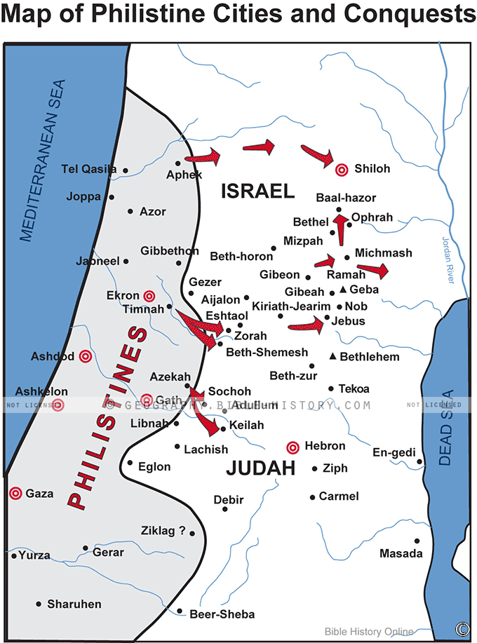

The "Map of Philistine Cities and Conquests" is a captivating cartographic representation that delves into the historical and geographical aspects of the Philistine civilization, a significant ancient Mediterranean culture. This meticulously crafted map serves as a window into the dynamic world of the Philistines, shedding light on their cities, territorial expansions, and influence in the ancient Levant region.
The map is exquisitely designed, with intricate details and vibrant colors that evoke a sense of the rich history and culture of the Philistines. It provides a visual narrative that allows viewers to journey through time, exploring the key elements of this formidable ancient civilization.
Key Features of the Map:
Philistine Cities:
The map prominently highlights the major Philistine cities that thrived during their heyday, such as Ashkelon, Gaza, Ashdod, Ekron, and Gath. Each city is represented with unique icons and labels, offering insights into their individual significance and contributions to the Philistine culture.
Territorial Expansions:
The map showcases the territorial conquests and expansions of the Philistines over time. Arrows and shaded areas illustrate the extent of their influence and control in the Levant region, providing a historical context for their interactions with neighboring civilizations, including the Israelites.
Trade Routes:
An intricate network of trade routes is depicted, revealing the Philistines' role as key traders and intermediaries between ancient Egypt, the Hittites, and other neighboring cultures. These routes contributed to the flourishing trade and cultural exchange that characterized Philistine society.
Archaeological Sites:
The map includes icons representing significant archaeological discoveries and excavation sites related to the Philistine civilization. This allows enthusiasts and scholars to trace the origins and evolution of this culture through tangible artifacts and historical evidence.
Natural Features:
Geographic elements such as rivers, mountains, and the Mediterranean coastline are meticulously detailed, providing context for the Philistines' choice of settlement locations and their interactions with the natural environment.
Historical Annotations:
Informative annotations and labels offer historical context and explanations for key events, cities, and regions on the map. These annotations make the map accessible to both experts and casual observers.
Timeline:
A timeline along the bottom or side of the map highlights significant events and developments in the history of the Philistine civilization, allowing viewers to understand its chronological progression.
Overall, the "Map of Philistine Cities and Conquests" is a captivating and informative visual resource that serves as a gateway to the intriguing world of the Philistines. Whether you are an archaeologist, historian, or simply a history enthusiast, this map provides a comprehensive and immersive experience, inviting you to explore the legacy and impact of this ancient civilization on the Mediterranean landscape.
Blank Topo Map of The World
Abraham’s Journey
The Captivity of Judah (586-516 B.C.)
The Fall of Judah 586 B.C.
The Northern Kingdom of Israel
The Southern Kingdom of Judah
The Divided Kingdom
The Fertile Crescent
Ur of the Chaldees
Shechem in Old Testament Times
Prophets, Kings, and Nations
Jesus Last Passover
New Testament Israel
New Testament Places
Old Testament Israel
Provinces of the Roman Empire
Israel during David’s Kingdom
David’s Kingdom
Cities of the New Testament 4
Cities of the New Testament 3
Cities of the New Testament 2
Mediterranean Sea
Cities of the New Testament
First Century Jerusalem
Empire of David and Solomon
David’s Kingdom
Israel Under Rehoboam
Ophir and Tarshish
The Period of the Kings
Ramoth Gilead
Samaria
Solomon’s Temple
Zarephath and MT Carmel
Jabesh Gilead and Tribes
Judah in the Time of David
Kingdom of Saul
Kirjath Jearim
Michmash
Mount Gilboa in the Time of David
Nob Davids Flight
Shiloh
Israel and Judah
Assyrian Empire Under Esarhaddon
Assyrian Empire Under Sennacherib
Captivity of 10 Tribes
Events in 2 Kings
The Khabur River
Israel and Syria
Captives From Judah
Kingdom of Jeroboam
Mesha’s Kingdom
Pharaoh Necho Battles King Josiah at Megiddo
Babylonian, Mede and Persian Empires
Samaria and Nearby Territories
Syria at its Height
Hebron
Mahanaim
1949 Map of Israel With Boundaries
First & Second Journeys of Paul
Journeys of the Apostles
Paul’s Third Missionary Journey
Saul’s Journey to Damascus and Arabia
Paul’s Final Visits
Paul’s 1st Missionary Journey
Paul’s 2nd Missionary Journey
Paul’s 3rd Missionary Journey
Paul’s Voyage to Rome
Phillip Journeys to Samaria and Gaza
Judah at the Time of Amos
Empire of Alexander the Great
Israel Under the Maccabees
Galilee During Maccabees
Idumea Intertestamental Period
Kingdom of the Ptolemies
Kingdom of the Seleucids
Ptolemaic Egypt Seleucid Asia
The Roman World
Kingdom of Ptolemies and Seleucids
The World During the 6TH Century BC
Mount Horeb
The Red Sea
The Exodus
Ezra’s Journey to Restore Jerusalem
Israel and Judah During Hosea’s Time
The Ancient World
Canaan During the Time of Abraham
The City of Shechem
Supposed Location of the Garden of Eden
The Land of Israel in Genesis
The Jordan River
The Kingdom of Nimrod
Mount Ararat and Mesopotamia
The Descendants
Sodom and Gomorrah
The Kingdom of Egypt
The Hamites
The Kingdom of the Hittites
Ur of the Chaldees
Judah at the Time of Haggai
Jesus Passes Through Samaria