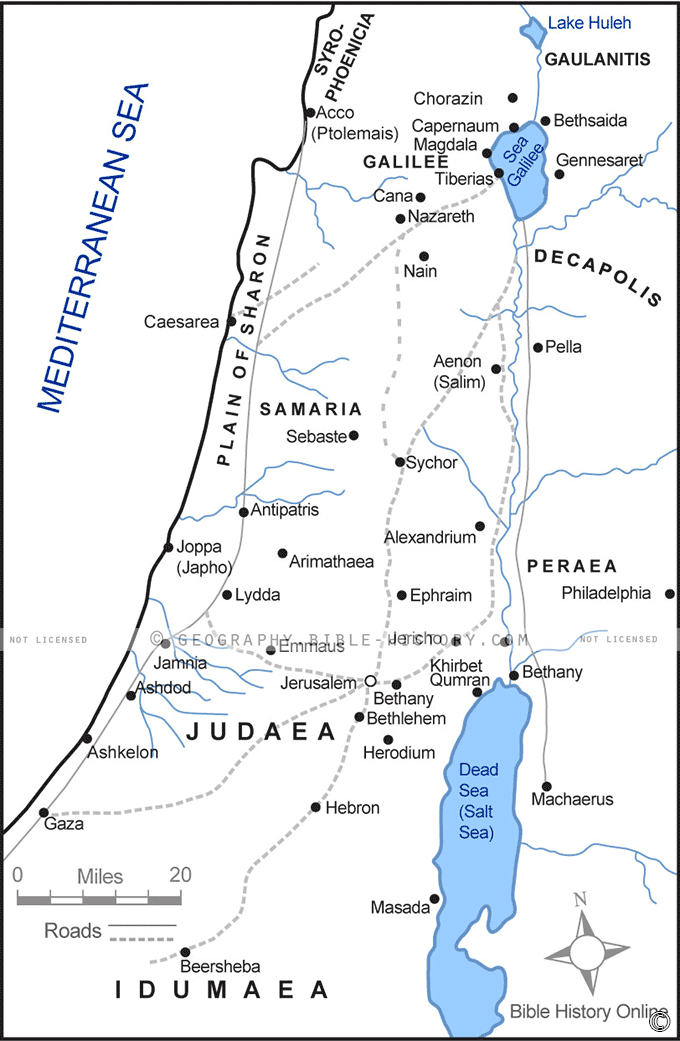

Our "Printable Map of Israel in the Time of Jesus" offers a captivating glimpse into the historical landscape of Judea during the life and ministry of Jesus Christ. This map serves as a valuable educational resource and a window to the past, inviting you to explore the rich history, culture, and spirituality of this iconic region.
Geographical Insights
This detailed map provides an intricate view of ancient Judea, offering insights into its geographical features, topography, and proximity to neighboring regions. Gain a deeper understanding of the terrain that played a pivotal role in the biblical narratives.
Biblical Significance
Step into the footsteps of Jesus as you navigate this map. Discover the locations where key events unfolded, from the serene shores of the Sea of Galilee, where Jesus walked on water, to the historic city of Jerusalem, where the Last Supper took place. Explore the connections between geography and faith.
Key Sites and Landmarks
As you journey through this map, you'll encounter significant sites such as Bethlehem, Nazareth, and the Jordan River. These locations are not only central to the life of Jesus but also hold cultural and spiritual importance in the Judeo-Christian tradition.
Educational Resource
Whether you're an educator, student, or simply curious about history and religion, this printable map is a valuable resource for learning and teaching about the historical context of Jesus' life and the early Christian era.
The "Printable Map of Israel in the Time of Jesus" is a portal to the past, offering an immersive experience of the region where faith, history, and culture converged. It provides a unique opportunity to explore the roots of Christianity and gain a deeper appreciation for the timeless stories that continue to inspire millions around the world.
Blank Topo Map of The World
Abraham’s Journey
The Captivity of Judah (586-516 B.C.)
The Fall of Judah 586 B.C.
The Northern Kingdom of Israel
The Southern Kingdom of Judah
The Divided Kingdom
The Fertile Crescent
Ur of the Chaldees
Shechem in Old Testament Times
Prophets, Kings, and Nations
Jesus Last Passover
New Testament Israel
New Testament Places
Old Testament Israel
Provinces of the Roman Empire
Israel during David’s Kingdom
David’s Kingdom
Cities of the New Testament 4
Cities of the New Testament 3
Cities of the New Testament 2
Mediterranean Sea
Cities of the New Testament
First Century Jerusalem
Empire of David and Solomon
David’s Kingdom
Israel Under Rehoboam
Ophir and Tarshish
The Period of the Kings
Ramoth Gilead
Samaria
Solomon’s Temple
Zarephath and MT Carmel
Jabesh Gilead and Tribes
Judah in the Time of David
Kingdom of Saul
Kirjath Jearim
Michmash
Mount Gilboa in the Time of David
Nob Davids Flight
Shiloh
Israel and Judah
Assyrian Empire Under Esarhaddon
Assyrian Empire Under Sennacherib
Captivity of 10 Tribes
Events in 2 Kings
The Khabur River
Israel and Syria
Captives From Judah
Kingdom of Jeroboam
Mesha’s Kingdom
Pharaoh Necho Battles King Josiah at Megiddo
Babylonian, Mede and Persian Empires
Samaria and Nearby Territories
Syria at its Height
Hebron
Mahanaim
1949 Map of Israel With Boundaries
First & Second Journeys of Paul
Journeys of the Apostles
Paul’s Third Missionary Journey
Saul’s Journey to Damascus and Arabia
Paul’s Final Visits
Paul’s 1st Missionary Journey
Paul’s 2nd Missionary Journey
Paul’s 3rd Missionary Journey
Paul’s Voyage to Rome
Phillip Journeys to Samaria and Gaza
Judah at the Time of Amos
Empire of Alexander the Great
Israel Under the Maccabees
Galilee During Maccabees
Idumea Intertestamental Period
Kingdom of the Ptolemies
Kingdom of the Seleucids
Ptolemaic Egypt Seleucid Asia
The Roman World
Kingdom of Ptolemies and Seleucids
The World During the 6TH Century BC
Mount Horeb
The Red Sea
The Exodus
Ezra’s Journey to Restore Jerusalem
Israel and Judah During Hosea’s Time
The Ancient World
Canaan During the Time of Abraham
The City of Shechem
Supposed Location of the Garden of Eden
The Land of Israel in Genesis
The Jordan River
The Kingdom of Nimrod
Mount Ararat and Mesopotamia
The Descendants
Sodom and Gomorrah
The Kingdom of Egypt
The Hamites
The Kingdom of the Hittites
Ur of the Chaldees
Judah at the Time of Haggai
Jesus Passes Through Samaria