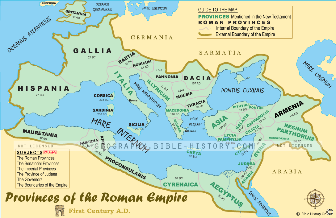

The map of the Provinces of the Roman Empire offers a comprehensive visual representation of one of the most expansive and influential empires in human history. The Roman Empire, at its height, spanned across three continents, and its provinces were the administrative units that facilitated its governance, trade, and cultural exchange. Here is a description of this historical map:
Geographical Extent:
This map provides a vast view of the Roman Empire's territorial expanse, covering regions in Europe, Asia, and Africa. It highlights the Mediterranean Basin as the heart of the empire.
Provincial Boundaries:
It outlines the boundaries of the various provinces that constituted the Roman Empire, showcasing the diversity of regions under Roman control, from Britannia in the north to Aegyptus in the south, and from Hispania in the west to Asia Minor in the east.
Administrative Centers:
The map features the administrative capitals and significant cities of each province, reflecting their importance in governance, trade, and culture. Notable cities like Rome, Alexandria, Carthage, and Ephesus are prominently marked.
Trade Routes and Roads:
It illustrates the network of roads and trade routes that connected the provinces, facilitating the movement of goods, people, and ideas throughout the empire.
Cultural and Religious Diversity:
The map showcases the rich tapestry of cultures, languages, and religions that coexisted within the Roman Empire. It was a melting pot of traditions, where local cultures often blended with Roman customs.
Historical Context:
This map serves as a visual portal into the historical context of the Roman Empire, including its rise, expansion, and eventual decline. It reflects key periods, such as the Pax Romana, and significant events like the Roman conquest of Gaul.
Economic Significance:
It indicates the provinces known for their economic contributions, such as grain production in Egypt, mining in Hispania, and trade in North Africa.
Military Presence:
The map may highlight the locations of Roman legions and military bases, demonstrating the strategic importance of various regions.
Cultural Achievements:
Exploring the map allows viewers to appreciate the architectural, artistic, and intellectual achievements of the Roman provinces, including temples, amphitheaters, and libraries.
The map of the Provinces of the Roman Empire offers a captivating journey through a vast and influential realm that shaped the course of Western civilization. It allows viewers to explore the geography, governance, and cultural diversity of this iconic empire, providing a deeper understanding of the historical legacy of Rome and the regions it governed.
Blank Topo Map of The World
Abraham’s Journey
The Captivity of Judah (586-516 B.C.)
The Fall of Judah 586 B.C.
The Northern Kingdom of Israel
The Southern Kingdom of Judah
The Divided Kingdom
The Fertile Crescent
Ur of the Chaldees
Shechem in Old Testament Times
Prophets, Kings, and Nations
Jesus Last Passover
New Testament Israel
New Testament Places
Old Testament Israel
Provinces of the Roman Empire
Israel during David’s Kingdom
David’s Kingdom
Cities of the New Testament 4
Cities of the New Testament 3
Cities of the New Testament 2
Mediterranean Sea
Cities of the New Testament
First Century Jerusalem
Empire of David and Solomon
David’s Kingdom
Israel Under Rehoboam
Ophir and Tarshish
The Period of the Kings
Ramoth Gilead
Samaria
Solomon’s Temple
Zarephath and MT Carmel
Jabesh Gilead and Tribes
Judah in the Time of David
Kingdom of Saul
Kirjath Jearim
Michmash
Mount Gilboa in the Time of David
Nob Davids Flight
Shiloh
Israel and Judah
Assyrian Empire Under Esarhaddon
Assyrian Empire Under Sennacherib
Captivity of 10 Tribes
Events in 2 Kings
The Khabur River
Israel and Syria
Captives From Judah
Kingdom of Jeroboam
Mesha’s Kingdom
Pharaoh Necho Battles King Josiah at Megiddo
Babylonian, Mede and Persian Empires
Samaria and Nearby Territories
Syria at its Height
Hebron
Mahanaim
1949 Map of Israel With Boundaries
First & Second Journeys of Paul
Journeys of the Apostles
Paul’s Third Missionary Journey
Saul’s Journey to Damascus and Arabia
Paul’s Final Visits
Paul’s 1st Missionary Journey
Paul’s 2nd Missionary Journey
Paul’s 3rd Missionary Journey
Paul’s Voyage to Rome
Phillip Journeys to Samaria and Gaza
Judah at the Time of Amos
Empire of Alexander the Great
Israel Under the Maccabees
Galilee During Maccabees
Idumea Intertestamental Period
Kingdom of the Ptolemies
Kingdom of the Seleucids
Ptolemaic Egypt Seleucid Asia
The Roman World
Kingdom of Ptolemies and Seleucids
The World During the 6TH Century BC
Mount Horeb
The Red Sea
The Exodus
Ezra’s Journey to Restore Jerusalem
Israel and Judah During Hosea’s Time
The Ancient World
Canaan During the Time of Abraham
The City of Shechem
Supposed Location of the Garden of Eden
The Land of Israel in Genesis
The Jordan River
The Kingdom of Nimrod
Mount Ararat and Mesopotamia
The Descendants
Sodom and Gomorrah
The Kingdom of Egypt
The Hamites
The Kingdom of the Hittites
Ur of the Chaldees
Judah at the Time of Haggai
Jesus Passes Through Samaria