
The map of Solomon's Temple offers a compelling visual representation of one of the most iconic and historically significant religious structures in the world. Solomon's Temple, also known as the First Temple, stood in Jerusalem as a central place of worship and the spiritual heart of ancient Israel for nearly four centuries.
Geographical Location:
The map provides a detailed layout of the Temple Mount in ancient Jerusalem, where Solomon's Temple once stood. It is situated in the southeastern part of the city and occupies a significant elevation.
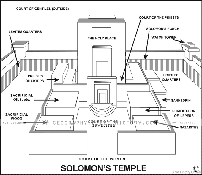
Temple Structure:
The map showcases the architectural features and layout of Solomon's Temple, which consisted of the main sanctuary, the Holy of Holies, the Holy Place, and the outer courtyards. The layout reflects the temple's sacred geometry and the division between the holy and most sacred spaces.
Courtyards and Gates:
The map highlights the various courtyards surrounding the temple complex, including the Court of the Priests, the Court of Israel, and the Court of the Gentiles. It also depicts the gates leading to these areas, such as the Beautiful Gate and the Nicanor Gate.
Altar and Brazen Sea:
The map features the Altar of Burnt Offering, where sacrifices were made, and the Brazen Sea, a massive bronze basin used for ritual purification. These were key elements of temple worship and are important components of the map.
Religious Significance:
This map serves as a visual portal into the religious and spiritual significance of Solomon's Temple. It was the dwelling place of the Ark of the Covenant and the central location for Jewish religious practices, including sacrifices and festivals.
Historical Context:
The map provides a historical context for Solomon's Temple, including its construction during the reign of King Solomon in the 10th century BCE and its eventual destruction by the Babylonians in 586 BCE. It also highlights the subsequent rebuilding efforts.
Cultural and Archaeological Insights:
Exploring the map allows viewers to gain insights into the culture, religious customs, and architectural achievements of ancient Israel. It also reflects the influence of neighboring cultures on the temple's design.
Modern Relevance:
The map may include markers or information related to the current state of the Temple Mount, including the presence of the Western Wall (Wailing Wall), which is a sacred site for Jewish worship and reflection.
The map of Solomon's Temple offers a captivating journey into a place of profound religious and historical significance. It allows viewers to explore the sacred spaces, architectural details, and cultural dimensions of this iconic structure, which continues to be a symbol of faith and heritage for millions around the world.
Blank Topo Map of The World
Abraham’s Journey
The Captivity of Judah (586-516 B.C.)
The Fall of Judah 586 B.C.
The Northern Kingdom of Israel
The Southern Kingdom of Judah
The Divided Kingdom
The Fertile Crescent
Ur of the Chaldees
Shechem in Old Testament Times
Prophets, Kings, and Nations
Jesus Last Passover
New Testament Israel
New Testament Places
Old Testament Israel
Provinces of the Roman Empire
Israel during David’s Kingdom
David’s Kingdom
Cities of the New Testament 4
Cities of the New Testament 3
Cities of the New Testament 2
Mediterranean Sea
Cities of the New Testament
First Century Jerusalem
Empire of David and Solomon
David’s Kingdom
Israel Under Rehoboam
Ophir and Tarshish
The Period of the Kings
Ramoth Gilead
Samaria
Solomon’s Temple
Zarephath and MT Carmel
Jabesh Gilead and Tribes
Judah in the Time of David
Kingdom of Saul
Kirjath Jearim
Michmash
Mount Gilboa in the Time of David
Nob Davids Flight
Shiloh
Israel and Judah
Assyrian Empire Under Esarhaddon
Assyrian Empire Under Sennacherib
Captivity of 10 Tribes
Events in 2 Kings
The Khabur River
Israel and Syria
Captives From Judah
Kingdom of Jeroboam
Mesha’s Kingdom
Pharaoh Necho Battles King Josiah at Megiddo
Babylonian, Mede and Persian Empires
Samaria and Nearby Territories
Syria at its Height
Hebron
Mahanaim
1949 Map of Israel With Boundaries
First & Second Journeys of Paul
Journeys of the Apostles
Paul’s Third Missionary Journey
Saul’s Journey to Damascus and Arabia
Paul’s Final Visits
Paul’s 1st Missionary Journey
Paul’s 2nd Missionary Journey
Paul’s 3rd Missionary Journey
Paul’s Voyage to Rome
Phillip Journeys to Samaria and Gaza
Judah at the Time of Amos
Empire of Alexander the Great
Israel Under the Maccabees
Galilee During Maccabees
Idumea Intertestamental Period
Kingdom of the Ptolemies
Kingdom of the Seleucids
Ptolemaic Egypt Seleucid Asia
The Roman World
Kingdom of Ptolemies and Seleucids
The World During the 6TH Century BC
Mount Horeb
The Red Sea
The Exodus
Ezra’s Journey to Restore Jerusalem
Israel and Judah During Hosea’s Time
The Ancient World
Canaan During the Time of Abraham
The City of Shechem
Supposed Location of the Garden of Eden
The Land of Israel in Genesis
The Jordan River
The Kingdom of Nimrod
Mount Ararat and Mesopotamia
The Descendants
Sodom and Gomorrah
The Kingdom of Egypt
The Hamites
The Kingdom of the Hittites
Ur of the Chaldees
Judah at the Time of Haggai
Jesus Passes Through Samaria